Loading...
Notice of Expiration of Redemption
NOTICE OF EXPIRATION OF REDEMPTION
TO: ALL PERSONS WITH A LEGAL INTEREST IN THE PARCELS OF REAL PROPERTY DESCRIBED IN THE FOLLOWING NOTICE
You are hereby notified that the parcels of real property described below and located in Lake of the Woods County, Minnesota, are subject to forfeiture to the state of Minnesota because of the nonpayment of delinquent property taxes, special assessments, penalties, interests, and costs levied on these parcels.
The time for redemption from forfeiture expires if a redemption is not made by the later of (1) 60 days after service of this notice on all persons having an interest in the parcels or (2) July 5, 2023.
The following information is listed below: the names of the property owners, taxpayers, and interest parties who have filed their addresses under M.S. 276.041; the addresses of the parties at the election of the county auditor; the legal description and parcel identification number of each parcel; and the amount necessary to redeem a parcel as of the date listed below.
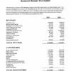
Namel Addresses PID and Description Arnount Due
Carl Hagen 02-2433-000 The West 450 feet of Government Lot 7, 3,492.39
1930 S 9th St Section 24, Township 168 North, Range 34 West of the
Missoula MT 59801 Fifth Principal Meridian,Less the West 150 thereof. Said tract contains 6.1 acres, more or less.
Northwest Angle
Carl Hagen 02-2433-011 The West 150 feet of Government Lot 7, Section 24, 1,379.24
1930 S 9th ST Township 168 North, Range 34 West of the Fifth Principal Meridian.
Missoula, MT 59801 Said tract contains 3.0 acres, more or less. Northwest Angle
Gregory & Betsy Fish 17-2011-010 A Tract of land in the NEI/4 NEI/4, Section 20, 2,460.74
9099 county RD 8 NW Township 162 North, Range 34, Described as follows:
Roosevelt, MN 56673 Beginning at the nortwest corner of NEI/4 NEI/4,Section 20, Township 162 North, Range 34; thence east along the north
Deutsche Bank National Trust line of said NEI/4 NEI/4 a distance of 225 feet to a point; thence
1761 East ST. Andrew Place south parallel to the west section line of section 20, a distance of
Santa Ana, CA 92705-4934 420 feet to a point; thence west parallel to the north line of said NEI/4 NEI/4 a distance of 225 feet to a point on the west line of NEI/4 NEI/4; thence north along the west line of NEI/4 NEI/4 a distance of 420 feet to the point of beginning. Such tract containing
2.169 acres, more or less.
Chilgren
Andrew S. Davidson 29-1631-010 The South 660 feet of the NE 1/4 SW 1/4, and the 1,126.39
Angela Bridges South 660 feet of the West 220 feet of the NW 1/4 SE 1/4,
PO Box 632 all located in Section 16, Township 160 North, Range 32 West
Baudette, MN 56623 of the Fifth Principal Meridian in Minnesota, according to the
United States Government Survey thereof, Lake of the Woods County,
Border State Bank Minnesota. Also including an easement for ingress and egress to and
PO Box 1089 from above described parcel, across and through the already existing
605 Main St W. driveway located on the Easterly 33 feet of the SE 1/4 SW 1/4 of said section
Baudette, MN 56623 16, Township 160 North, Range 32 West. Walhalla
Bennie & Donna Boeshans 37-3032-010 East 330 feet of Government lot 3 and east 330 Feet 605.6
C/O Sheryl Meyer of Government lot 4, Section 30, Township 159 North, Range 31
10185 Stonebridge TRL N West.
Stillwater, MN 55082 Boone
Bennie & Donna Boeshans 37-3122-010 East one-half (El/2) of Government lot 1, of Section 1,442.83
C/O Sheryl Meyer 31, Township 159 North, Range 31 West of the 5th Principal
10185 Stonebridge TRL N Meridian, Minnesota.
Stillwater, MN 55082 Boone
Henry B. House 49-2231-000 Southwest quarter of Section twenty-two 1,230.12
C/O Lereta/Texas Operations in Township one hundred fifty-seven north of Range Thirty-One
PO Box 35605 west of the Fifth Principal Meridian, Minnesota, containing one
Dallas, TX 75235 hundred sixty acres.
Keil
Border Concrete, LLC 64-0322-050 The part of Government Lot 4, Section 3, Township 160 3,882.34
29263 County Road 5 North, Range 31 West of the Fifth Principal Meridian, Lake of the Woods
Warroad, MN 56763 County, Minnesota, described as follows: Commencing at the Northwest corner of said Section 3; thence on an assumed bearing of South 00 degrees
Lunda Construction Company 07 minutes 04 seconds East along the west line of said Section 3 a distace
620 Gebhardt Road 513.60 feet to the point of beginning; thence North 86 degrees 14 minutes
PO Box 669 56 seconds East parallel with the old South right-of-way line of Trunk Highway
Black River Falls, WI 54615-0699 number 11 a distance of 500.00 feet to the Southeast corner of Clarence Larson property as recorded in Document Number 37640, Book 32, Page 423 in Lake of the Woods County Recorder's Office; thence South 00 degrees 07 minutes 04 seconds East parallel with the west fine of said Section 3 a distance of 560.44 feet; thence north 89 degrees 50 minutes 50 seconds West a distance of 499.00 feet to the west line of said Section 3; thence North 00 degrees 07 minutes 04 seconds West along the west line of said Section 3 a distance of 560.44 feet to the point of beginning. Containing 6.23 acres, more or less.
Baudette City
FAILURE TO REDEEM SUCH LANDS PRIOR TO THE EXPIRATION OF REDEMPTION WILL RESULT IN THE LOSS OF THE LAND AND FORFEITURE TO THE STATE OF MINNESOTA
The amounts listed above must be paid to redeem if paid on or before April 30, 2023. Please contact the Lake of the Woods County Auditor/Treasurer's Office to verify the amount due if paid after April 30, 2023.
Inquiries about the delinquent tax proceedings described above can be made to the Lake of the Woods County Auditor/Treasurer's Office at the address listed below.
Witness my hand and official seal this 3rd_ day of April, 2023.
Lorene G. Hanson
Lake of the Woods County Auditor/Treasurer
206 8th Ave SE, Suite 260 Baudette, MN 56623
Telephone: (218)634-2836
Please support The Northern Light Region by subscribing today!
You may also like: